 Código de Endereçamento Postal (CEP) Brazil
Discover Código de Endereçamento Postal (CEP) Brazil across States and Cities. Instantly retrieve CEP codes with interactive address lookup tool.
Código de Endereçamento Postal (CEP), which translates to "Postal Addressing Code" in English, is a crucial part of Brazil's postal system. It's a system designed to organize mail, ensuring that it gets delivered quickly and efficiently throughout the country. The idea behind CEP was to make the delivery process smoother, especially considering Brazil's vast and varied geography. By giving each region its own unique code, CEP has made a big difference in how accurately and promptly mail gets delivered. Please refer to the table below to Find the CEPs of all major cities in Brazil, along with an interactive map showcasing the postal regions across Brazil.
To find a comprehensive list of CEP Codes in Brazil, please refer to the table below or click on any location on the Interactive map to instantly find the postal code for your mail's destination.
List of CEP Codes in Brazil
| State | ISO code | CEP (Range) | Count |
|---|---|---|---|
| Acre | AC | 69900-000 to 69990-000 | 22 |
| Alagoas | AL | 57000-000 to 57995-000 | 101 |
| Amapa | AP | 68900-000 to 68997-000 | 16 |
| Amazonas | AM | 69000-000 to 69895-000 | 62 |
| Bahia | BA | 40000-000 to 48990-000 | 415 |
| Ceara | CE | 60000-000 to 63970-000 | 184 |
| Distrito Federal | DF | 70000-000 to 73300-000 | 19 |
| Espirito Santo | ES | 29000-000 to 29980-000 | 77 |
| Goias | GO | 72800-000 to 76740-000 | 242 |
| Maranhao | MA | 65000-000 to 65995-000 | 217 |
| Mato Grosso | MT | 78000-000 to 78890-000 | 126 |
| Mato Grosso do Sul | MS | 79000-000 to 79995-000 | 77 |
| Minas Gerais | MG | 30000-000 to 39998-000 | 853 |
| Para | PA | 66000-000 to 68890-000 | 143 |
| Paraiba | PB | 58000-000 to 58995-000 | 223 |
| Parana | PR | 80000-000 to 87990-000 | 399 |
| Pernambuco | PE | 50000-000 to 56980-000 | 185 |
| Piaui | PI | 64000-000 to 64995-000 | 221 |
| Rio de Janeiro | RJ | 20000-000 to 28990-000 | 91 |
| Rio Grande do Norte | RN | 59000-000 to 59995-000 | 166 |
| Rio Grande do Sul | RS | 90000-000 to 99990-000 | 467 |
| Rondonia | RO | 78900-000 to 78999-000 | 52 |
| Roraima | RR | 69300-000 to 69390-000 | 15 |
| Santa Catarina | SC | 88000-000 to 89998-000 | 293 |
| Sao Paulo | SP | 01000-000 to 19990-000 | 645 |
| Sergipe | SE | 49000-000 to 49995-000 | 75 |
| Tocantins | TO | 77000-000 to 77995-000 | 139 |
Interactive Map of CEP Brazil
Interactive CEP code lookup Map: Simply click on any location on the map to instantly reveal its CEP code and address details. For a more immersive experience, engage Fullscreen mode to maximize your exploration capabilities and enable smooth navigation with scroll gestures.
Format of CEP Brazil
The CEP started in 1972 with just five numbers. But in 1992, it was expanded to eight numbers to make locations more precise. The format is “nnnnn-nnn”, where the first five numbers are followed by a hyphen and then three more numbers. Each number in the first part stands for a different area, like a region or sector. The last three numbers help with distribution.
Big cities with lots of people have a CEP for every public place and some private places too, like big buildings and condos. Small towns have a general 5-number code that ends with -000.
History of CEP Brazil
The Brazilian Post and Telegraph Corporation made the CEP in May 1971. It started with just five numbers. The system was made to help sort and deliver mail, so the postal service could get letters and packages to the right place quickly and easily.
In May 1992, the Brazilian postal code changed to eight numbers to make locations more precise. This change was a big moment in the history of the CEP.
Implementation of CEP Brazil
The CEP has really helped make mail delivery in Brazil more efficient. The full postal code database, called DNE, has more than 900,000 codes. It includes streets, neighborhoods, cities, and state names. At first, it was free on the Brazilian post office website. But after some improvements, it’s now a paid service called e-DNE.
Brazil was split into ten postal areas for coding. This was done based on things like how much each state was growing and developing. The CEPs were given out starting from the state of São Paulo and going counter-clockwise.
When giving out CEPs, the Correios group cities, districts, and villages into areas. Most of these areas are split into urban and rural parts. Cities with just one CEP use the same code for mail going to rural areas. But for cities with codes for specific streets that include rural areas, a special CEP is used.
Helpful Resources:

Official website - correios
The Official website of correios provides comprehensive information and resources about the Postal code system in Brazil. This site allows users to search for postal codes, access forms, and find detailed guidelines on how to correctly use zip codes for efficient mail delivery within Brazil.
correios.com.br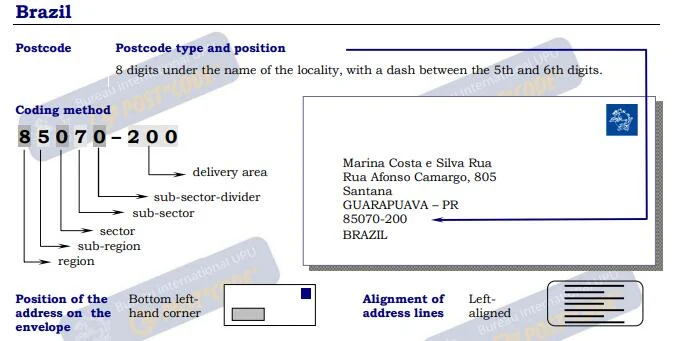
Guidelines for Addressing Mail in Brazil
This document from UPU provides comprehensive guidelines for correctly addressing mail within Brazil. It includes detailed instructions on the format and positioning of the 5+3-digit postcodes, recommendations for font sizes and spacing, and examples of various address formats, including those for rural areas and P.O. Boxes. The document ensures mail is properly sorted and delivered, offering practical examples for different scenarios and contact information for further assistance.
Universal Postal Union
Postal codes in Brazil - Wikipedia
The "Código de Endereçamento Postal" Wikipedia Page offers detailed information about the Postal code system in Brazil. This page provides the structure of postal codes, and examples of how they are used across different regions. It serves as a comprehensive resource for understanding the organization and application of postal codes within Brazil.
Wikipedia
Country codes and Abbreviations - Brazil (BR)
The Brazil country codes Page provides Abbreviations and country codes including ISO codes, dialing codes, TLD, currency codes, time zones, neighboring countries, etc. Access essential information efficiently for streamlined referencing and exploration.
codesofcountry.com
Brazil - Wikipedia
The Brazil Wikipedia Page provides a comprehensive overview of the country, including its history, geography, culture, economy, and more. This page offers detailed information and is regularly updated to reflect the latest developments and insights about Brazil. It serves as a valuable resource for anyone looking to learn more about Brazil.
Wikipedia


