 Bangladesh Postal codes
Discover Bangladesh Postal Codes across Districts. Instantly retrieve Bangladesh Postal codes with interactive Postal code lookup Map.
Bangladesh, a populous South Asian nation with a rich cultural heritage and a rapidly growing economy, relies on an efficient postal system to facilitate communication and commerce across its diverse landscape. At the heart of this system lie Bangladesh postal codes, Numeric identifiers assigned to specific geographic areas to streamline the sorting and delivery of mail and parcels. In this comprehensive overview, we delve into the intricacies of Bangladesh postal codes, exploring their format, historical development, implementation, and the role they play in enhancing the efficiency of the country's postal services.
To find a comprehensive list of Postal codes in Bangladesh, please refer to the table below or click on any location on the Interactive map to instantly find the postal code and address for your mail's destination:
List of Postal codes in Bangladesh
| District | Postal codes (Range) | Offices |
|---|---|---|
| Bagherhat | 9300 to 9385 | 26 |
| Bandarban | 4600 to 4660 | 7 |
| Barguna | 8700 to 8741 | 8 |
| Barishal | 8200 to 8284 | 41 |
| Bhola | 8300 to 8360 | 14 |
| Bogra | 5800 to 5892 | 20 |
| Brahmanbaria | 3400 to 3464 | 28 |
| Chandpur | 3600 to 3661 | 26 |
| Chapinawabganj | 6300 to 6342 | 12 |
| Chittagong | 4000 to 4398 | 99 |
| Chuadanga | 7200 to 7230 | 8 |
| Comilla | 3500 to 3583 | 38 |
| Cox’s Bazar | 4700 to 4762 | 14 |
| Dhaka | 1000 to 1362 | 51 |
| Dinajpur | 5200 to 5291 | 19 |
| Faridpur | 7800 to 7870 | 17 |
| Feni | 3900 to 3943 | 20 |
| Gaibandha | 5700 to 5761 | 12 |
| Gazipur | 1700 to 1751 | 23 |
| Gopalganj | 8013 to 8142 | 14 |
| Hobiganj | 3300 to 3374 | 22 |
| Jamalpur | 2000 to 2055 | 20 |
| Jessore | 7400 to 7471 | 21 |
| Jhalokathi | 8400 to 8433 | 12 |
| Jinaidaha | 7300 to 7351 | 9 |
| Joypurhat | 5900 to 5942 | 7 |
| Khagrachari | 4400 to 4470 | 8 |
| Khulna | 9000 to 9291 | 39 |
| Kishoreganj | 2300 to 2390 | 21 |
| Kurigram | 5600 to 5680 | 13 |
| Kustia | 7000 to 7052 | 17 |
| Lakshmipur | 3700 to 3732 | 24 |
| Lalmonirhat | 5500 to 5542 | 9 |
| Madaripur | 7900 to 7933 | 13 |
| Magura | 7600 to 7632 | 8 |
| Manikganj | 1800 to 1860 | 18 |
| Meherpur | 7100 to 7152 | 5 |
| Moulvibazar | 3200 to 3253 | 26 |
| Munshiganj | 1333 to 1558 | 38 |
| Mymensingh | 2200 to 2291 | 31 |
| Naogaon | 6500 to 6597 | 18 |
| Narail | 7500 to 7521 | 9 |
| Narayanganj | 1400 to 1464 | 21 |
| Narshingdi | 1600 to 1652 | 18 |
| Natore | 6400 to 6450 | 13 |
| Netrakona | 2400 to 2490 | 18 |
| Nilphamari | 5300 to 5351 | 10 |
| Noakhali | 3800 to 3892 | 58 |
| Pabna | 6600 to 6683 | 18 |
| Panchagarh | 5000 to 5041 | 6 |
| Patuakhali | 8600 to 8651 | 15 |
| Pirojpur | 8500 to 8566 | 25 |
| Rajbari | 7700 to 7731 | 9 |
| Rajshahi | 6000 to 6291 | 23 |
| Rangamati | 4500 to 4590 | 14 |
| Rangpur | 5400 to 5460 | 14 |
| Satkhira | 9400 to 9461 | 25 |
| Shariatpur | 8000 to 8050 | 12 |
| Sherpur | 2100 to 2151 | 8 |
| Sirajganj | 6700 to 6780 | 23 |
| Sunamganj | 3000 to 3893 | 26 |
| Sylhet | 3100 to 3191 | 54 |
| Tangail | 1900 to 1997 | 43 |
| Thakurgaon | 5100 to 5470 | 11 |
Interactive Map of Bangladesh Postal codes
Interactive Postal code lookup Map: Simply click on any location on the map to instantly reveal its Postal code and address details. For a more immersive experience, engage Fullscreen mode to maximize your exploration capabilities and enable smooth navigation with scroll gestures.
Format of Bangladesh Postal Codes:
Bangladesh postal codes follow a standardized format consisting of four digits, typically represented as XXXX. Each digit within the code serves a distinct purpose, delineating various geographic divisions within the country. The first two digits of the postal code denote the division, providing a broad categorization of regions across Bangladesh. These divisions encompass administrative boundaries and serve as a primary organizational structure for the postal system.
Moving further, the next two digits of the postal code represent the district, offering a more granular identification of specific areas within each division. This level of detail enables postal authorities to accurately pinpoint the destination of mail and parcels, facilitating efficient sorting and routing processes.
History of Bangladesh Postal Codes:
The introduction of postal codes in Bangladesh marks a significant milestone in the evolution of the country's postal infrastructure. The need for a standardized system to manage the burgeoning volume of mail became apparent in the late 1970s, prompting the Bangladesh Postal Service to embark on the development of a comprehensive postal code system.
Over the years, the postal code system has undergone iterative refinements and enhancements to align with the changing demographics and infrastructure of Bangladesh. Initially implemented on a limited scale, postal codes gradually gained widespread adoption across the country, becoming an indispensable tool for postal workers, businesses, and individuals alike.
Implementation of Postal Codes in Bangladesh:
The implementation of postal codes in Bangladesh involved a meticulous process of assigning unique identifiers to geographic regions, districts, and sub-districts. Drawing upon existing administrative divisions and geographic boundaries, postal authorities devised a hierarchical system of codes that accurately reflected the country's diverse landscape.
Key stakeholders, including government agencies, postal workers, and local communities, played integral roles in the implementation process, contributing insights and expertise to ensure the effectiveness and accuracy of the postal code system. Through extensive outreach and education initiatives, postal authorities sought to familiarize the public with the new system, emphasizing its benefits in terms of mail delivery efficiency and accuracy.
Today, the postal code system stands as a cornerstone of Bangladesh's postal infrastructure, facilitating seamless communication and logistics operations across the country. With ongoing advancements in technology and infrastructure, postal authorities continue to refine and optimize the postal code system, ensuring its relevance and effectiveness in an increasingly interconnected world.
Role of Bangladesh Postal Codes in Enhancing Mail Delivery Efficiency:
Bangladesh postal codes play a pivotal role in enhancing the efficiency of the country's mail delivery services. By providing a standardized framework for addressing mail and parcels, postal codes enable automated sorting and routing processes, reducing the likelihood of errors and delays in delivery.
Postal workers rely on postal codes to accurately identify the destination of mail and parcels, streamlining the distribution process and optimizing resource allocation. Furthermore, businesses and individuals benefit from the use of postal codes when sending and receiving mail, ensuring that correspondence reaches its intended recipients in a timely manner.
Moreover, the adoption of postal codes has facilitated the integration of Bangladesh's postal system with global networks, enabling seamless international mail delivery and fostering cross-border trade and communication.
Helpful Resources:

Official website - bdpost
The Official website of bdpost provides comprehensive information and resources about the Postal code system in Bangladesh. This site allows users to search for postal codes, access forms, and find detailed guidelines on how to correctly use zip codes for efficient mail delivery within Bangladesh.
bdpost.gov.bd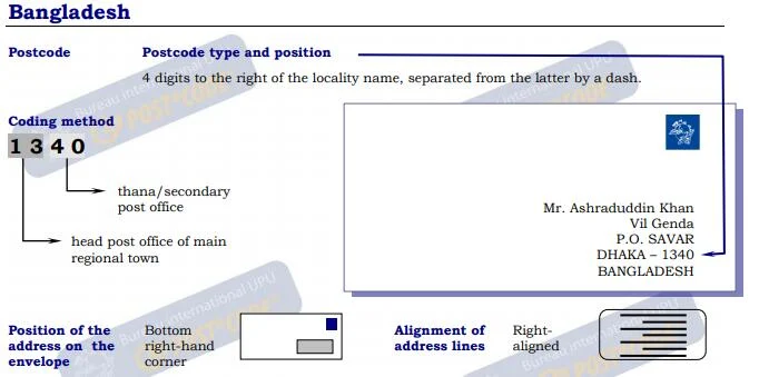
Guidelines for Addressing Mail in Bangladesh
This document from UPU provides comprehensive guidelines for correctly addressing mail within Bangladesh. It includes detailed instructions on the format and positioning of the 4-digit postcodes, recommendations for font sizes and spacing, and examples of various address formats, including those for rural areas and P.O. Boxes. The document ensures mail is properly sorted and delivered, offering practical examples for different scenarios and contact information for further assistance.
Universal Postal Union
Postal codes in Bangladesh - Wikipedia
The "Postal codes in Bangladesh" Wikipedia Page offers detailed information about the Postal code system in Bangladesh. This page provides the structure of postal codes, and examples of how they are used across different regions. It serves as a comprehensive resource for understanding the organization and application of postal codes within Bangladesh.
Wikipedia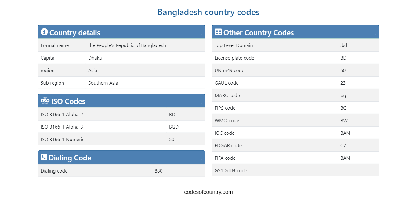
Country codes and Abbreviations - Bangladesh (BD)
The Bangladesh country codes Page provides Abbreviations and country codes including ISO codes, dialing codes, TLD, currency codes, time zones, neighboring countries, etc. Access essential information efficiently for streamlined referencing and exploration.
codesofcountry.com
Bangladesh - Wikipedia
The Bangladesh Wikipedia Page provides a comprehensive overview of the country, including its history, geography, culture, economy, and more. This page offers detailed information and is regularly updated to reflect the latest developments and insights about Bangladesh. It serves as a valuable resource for anyone looking to learn more about Bangladesh.
Wikipedia


